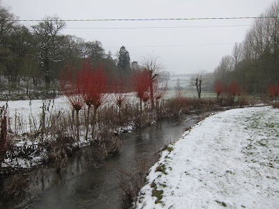
This walk is over the hills of Cam long down and Uley bury and into Petty Helger's Tump puts me in touch with the old history of the people of the cotwold escarpment. The landscape worked since the iron age is unique in my experience.
There's a car park at the bottom of peaked down which is a good place to start. The pub in Uley, the Old Crown Inn, serves the local beer and a decent lunch.
Name: 09/12/2012 11:22>Total distance: 9.02 km (5.6 mi)
Total time: 2:17:50
Moving time: 2:01:26
Average speed: 3.93 km/h (2.4 mi/h)
Average moving speed: 4.46 km/h (2.8 mi/h)
Max speed: 10.50 km/h (6.5 mi/h)
Average pace: 15.28 min/km (24.6 min/mi)
Average moving pace: 13.46 min/km (21.7 min/mi)
Fastest pace: 5.72 min/km (9.2 min/mile)
Max elevation: 297 m (975 ft)
Min elevation: 162 m (530 ft)
Elevation gain: 361 m (1186 ft)
Max grade: 23 %
Min grade: 3 %
Recorded: 09/12/2012 11:22
View 09/12/2012 11:22 in a larger map
Sunday 9 December 2012
Sunday 2 December 2012
Broadway
This walk was with American friends who wanted to see some of the English countryside. Broadway tower seems appropriate.
Total distance: 10.85 km (6.7 mi)
Total time: 2:58:24
Moving time: 2:43:01
Average speed: 3.65 km/h (2.3 mi/h)
Average moving speed: 3.99 km/h (2.5 mi/h)
Max speed: 13.97 km/h (8.7 mi/h)
Average pace: 16.45 min/km (26.5 min/mi)
Average moving pace: 15.03 min/km (24.2 min/mi)
Fastest pace: 4.29 min/km (6.9 min/mile)
Max elevation: 360 m (1182 ft)
Min elevation: 123 m (404 ft)
Elevation gain: 445 m (1461 ft)
Max grade: 6 %
Min grade: -1 %
Recorded: 02/12/2012 10:14
View 02/12/2012 10:14 in a larger map
Sunday 14 October 2012
Marcle Ridge
This walk was part of a day out to the Big Apple festival in Much Marcle. The walk was found on the web here but our route involved a bit of additional getting lost. All was much improved by a lunch in the Slip Tavern and a trip around the Westons Cider factory.


 Created by My Tracks on Android.
Total time: 1:58:48
Moving time: 1:53:20
Average speed: 4.63 km/h (2.9 mi/h)
Average moving speed: 4.86 km/h (3.0 mi/h)
Max speed: 12.24 km/h (7.6 mi/h)
Average pace: 12.95 min/km (20.8 min/mi)
Average moving pace: 12.36 min/km (19.9 min/mi)
Fastest pace: 4.90 min/km (7.9 min/mile)
Max elevation: 285 m (936 ft)
Min elevation: 140 m (459 ft)
Elevation gain: 300 m (983 ft)
Max grade: 2 %
Min grade: -5 %
Recorded: 14/10/2012 11:10
View 14/10/2012 11:10 in a larger map


Name: 14/10/2012 11:10
Total distance: 9.17 km (5.7 mi)Total time: 1:58:48
Moving time: 1:53:20
Average speed: 4.63 km/h (2.9 mi/h)
Average moving speed: 4.86 km/h (3.0 mi/h)
Max speed: 12.24 km/h (7.6 mi/h)
Average pace: 12.95 min/km (20.8 min/mi)
Average moving pace: 12.36 min/km (19.9 min/mi)
Fastest pace: 4.90 min/km (7.9 min/mile)
Max elevation: 285 m (936 ft)
Min elevation: 140 m (459 ft)
Elevation gain: 300 m (983 ft)
Max grade: 2 %
Min grade: -5 %
Recorded: 14/10/2012 11:10
View 14/10/2012 11:10 in a larger map
Sunday 30 September 2012
Stroud Five Valleys
After meaning to do this walk for a number of years, finally got down to Nailsworth for the Meningitis Trust Five Valleys Walk. Was a lovely autumn day and the local support for was very good with tea and cake stops, even a beer tent at half way. Stopped at the Old Fleece on the way back for a decent late Sunday lunch.
View 30/09/2012 09:56 in a larger map
Created by My Tracks on Android.
Name: 30/09/2012 09:56
Activity type: -
Description: -
Total distance: 19.35 km (12.0 mi)
Total time: 3:45:07
Moving time: 3:38:21
Average speed: 5.16 km/h (3.2 mi/h)
Average moving speed: 5.32 km/h (3.3 mi/h)
Max speed: 12.73 km/h (7.9 mi/h)
Average pace: 11.63 min/km (18.7 min/mi)
Average moving pace: 11.28 min/km (18.2 min/mi)
Fastest pace: 4.71 min/km (7.6 min/mile)
Max elevation: 301 m (989 ft)
Min elevation: 108 m (355 ft)
Elevation gain: 708 m (2322 ft)
Max grade: 7 %
Min grade: -4 %
Recorded: 30/09/2012 09:56
View 30/09/2012 09:56 in a larger map
Sunday 16 September 2012
Hidcote
This walk starts from the car park of Hidcote Gardens, a National Trust property, and well worth a visit. The walk was one of our own.


Created by My Tracks on Android.
View 16/09/2012 12:40 in a larger map


Created by My Tracks on Android.
Name: 16/09/2012 12:40
Total distance: 8.47 km (5.3 mi)
Total time: 1:44:47
Moving time: 1:30:34
Average speed: 4.85 km/h (3.0 mi/h)
Average moving speed: 5.61 km/h (3.5 mi/h)
Max speed: 10.06 km/h (6.3 mi/h)
Average pace: 12.37 min/km (19.9 min/mi)
Average moving pace: 10.69 min/km (17.2 min/mi)
Fastest pace: 5.96 min/km (9.6 min/mile)
Max elevation: 311 m (1021 ft)
Min elevation: 221 m (726 ft)
Elevation gain: 217 m (713 ft)
Max grade: 11 %
Min grade: -13 %
Recorded: 16/09/2012 12:40
View 16/09/2012 12:40 in a larger map
Sunday 24 June 2012
Cheltenham Circular Challenge
This walk is the first half of the Cheltenham Circular Challenge. We've walked this many times in rain and shine, well worth doing for the views and well worth supporting the Rotary guys, maps on their site. The WI cake stalls are always worth a visit. You could do this walk any time but there's a free bus service on Challenge day.
Created by My Tracks on Android.
Total distance: 21.82 km (13.6 mi)
Total time: 3:58:57
Moving time: 3:43:56
Average speed: 5.48 km/h (3.4 mi/h)
Average moving speed: 5.85 km/h (3.6 mi/h)
Max speed: 16.60 km/h (10.3 mi/h)
Average pace: 10.95 min/km (17.6 min/mi)
Average moving pace: 10.26 min/km (16.5 min/mi)
Min pace: 3.62 min/km (5.8 min/mi)
Max elevation: 340 m (1116 ft)
Min elevation: 98 m (322 ft)
Elevation gain: 802 m (2632 ft)
Max grade: 0 %
Min grade: 0 %
View 24/06/2012 09:06 in a larger map
Sunday 27 May 2012
Ashleworth
This walk started from the Red Lion at Wainlode. Parking is a bit limited unless you stop in the pub. The route follows the Severn Way south to Ashleworth then returns cross country. A tantalizing view of the pub from half way around, but no way to cross the river. Our plan was to visit the Boat Inn at Ashleworth that was running it's annual beer festival. Beautiful weather for sitting by the river.
The route shown includes the drive to the pub.


View 27/05/2012 10:49 in a larger map


View 27/05/2012 10:49 in a larger map
Sunday 22 April 2012
Ashton under hill
This walk from Aston Under Hill. Had lunch at the Star Inn.


 Created by My Tracks on Android.
View 22/04/2012 10:03 in a larger map


Total distance: 11.36 km (7.1 mi)
Total time: 2:25:52
Moving time: 2:24:10
Average speed: 4.67 km/h (2.9 mi/h)
Average moving speed: 4.73 km/h (2.9 mi/h)
Max speed: 11.70 km/h (7.3 mi/h)
Average pace: 12.84 min/km (20.7 min/mi)
Average moving pace: 12.69 min/km (20.4 min/mi)
Min pace: 5.13 min/km (8.3 min/mi)
Max elevation: 328 m (1076 ft)
Min elevation: 102 m (335 ft)
Elevation gain: 176 m (577 ft)
Max grade: 11 %
Min grade: -8 %
Recorded: 22/04/2012 10:03
View 22/04/2012 10:03 in a larger map
Sunday 15 April 2012
River Severn (North from Bushley)
This walk started from the village hall in Bushley up the river bank to Upton on Severn.
View 15/04/2012 10:30 in a larger map
View 15/04/2012 10:30 in a larger map
Monday 9 April 2012
Sunday 25 March 2012
Cranham Woods
A rather damp walk on Easter Monday starting from Cranham common and round to the Chedworth villa. The bluebells were out in abundance. Lunch was at the Black Horse.
Black horse, bluebells
View 25/03/2012 10:47 in a larger map
Black horse, bluebells
View 25/03/2012 10:47 in a larger map
Sunday 19 February 2012
Coln Rogers to Saltway
Today's walk was another from walkweb starting at Coln Rogers. The walk starts and ends at from a pretty Saxon church close to the river. It looks like spring is coming. Lunch was as at the Fossebridge Inn which we'd spotted last week.


Created by My Tracks on Android.
Total distance: 7.86 km (4.9 mi)
Total time: 1:34:26
Moving time: 1:33:35
Average speed: 4.99 km/h (3.1 mi/h)
Average moving speed: 5.04 km/h (3.1 mi/h)
Max speed: 9.57 km/h (5.9 mi/h)
Min elevation: 108 m (353 ft)
Max elevation: 208 m (681 ft)
Elevation gain: 54 m (178 ft)
Max grade: 5 %
Min grade: -2 %
Recorded: 19/02/2012 10:37
View 19/02/2012 10:37 in a larger map
Sunday 12 February 2012
Chedworth Roman Villa via Withington
Today's walk is from Walkweb but we started from the Chedworth Roman villa. The road up was very icy and the villa was closed at this time of year but it was nice walking in the snowy conditions. We discovered a really good pub, the Seven Tuns at Chedworth, so it is worth considering starting from there.


 Cant figure out how to merge my maps, but here's the route from the start to the pub.
View 12/02/2012 10:51 in a larger map


View 12/02/2012 10:51 in a larger map
Sunday 5 February 2012
Winchcombe towards Farmcote
There had been a fall of snow overnight so we decided to walk locally up onto the Cotswold escarpment from Winchcombe towards Farmcote Wood. Little snow had settled and it was melting as we walked, we were lucky to catch it and the conditions were still and mild. All the pubs in town were fully booked so we stopped at the Rising Sun on Cleeve Hill.


Created by My Tracks on Android.
Total distance: 11.77 km (7.3 mi)
Total time: 2:55:38
Moving time: 2:54:15
Average speed: 4.02 km/h (2.5 mi/h)
Average moving speed: 4.05 km/h (2.5 mi/h)
Max speed: 11.70 km/h (7.3 mi/h)
Min elevation: 133 m (438 ft)
Max elevation: 337 m (1105 ft)
Elevation gain: 211 m (692 ft)
Max grade: 11 %
Min grade: -7 %
Recorded: 2/5/12 10:24 AM
View 2/5/12 10:24 AM in a larger map
Sunday 29 January 2012
Painswick Beacon & Rococo Gardens
This walk started and ended at the Rococo Gardens in Painswick. The walk was courtesy of their website, see the link here The main reason for the trip was to see the snowdrops which were at their best. The walk passes the Royal William pub at Cranham so we went back for lunch.


Created by My Tracks on Android.
Total distance: 10.65 km (6.6 mi)
Total time: 2:15:01
Moving time: 1:48:04
Average speed: 4.73 km/h (2.9 mi/h)
Average moving speed: 5.91 km/h (3.7 mi/h)
Max speed: 17.19 km/h (10.7 mi/h)
Min elevation: 134 m (440 ft)
Max elevation: 330 m (1084 ft)
Elevation gain: 462 m (1516 ft)
Max grade: 0 %
Min grade: 0 %
Recorded: 1/29/12 10:34 AM
View 1/29/12 10:34 AM in a larger map


Created by My Tracks on Android.
Total time: 2:15:01
Moving time: 1:48:04
Average speed: 4.73 km/h (2.9 mi/h)
Average moving speed: 5.91 km/h (3.7 mi/h)
Max speed: 17.19 km/h (10.7 mi/h)
Min elevation: 134 m (440 ft)
Max elevation: 330 m (1084 ft)
Elevation gain: 462 m (1516 ft)
Max grade: 0 %
Min grade: 0 %
Recorded: 1/29/12 10:34 AM
View 1/29/12 10:34 AM in a larger map
Sunday 15 January 2012
Half Way House, Kineton
This walk was started from a lay-by at Stumps Cross. There are several good pubs close by but we ended up in the Half Way House. They do a very decent Sunday roast. There was frost on the ground as we walked but the sun was out. A corn field of small birds provided an great display as the flocked swooped.


Created by My Tracks on Android.
View 1/15/12 10:30 AM in a larger map


Created by My Tracks on Android.
Total distance: 10.60 km (6.6 mi)
Total time: 2:14:56
Moving time: 1:53:40
Average speed: 4.71 km/h (2.9 mi/h)
Average moving speed: 5.59 km/h (3.5 mi/h)
Max speed: 13.74 km/h (8.5 mi/h)
Min elevation: 151 m (494 ft)
Max elevation: 355 m (1166 ft)
Elevation gain: 455 m (1492 ft)
Max grade: 20 %
Min grade: -9 %
Recorded: 1/15/12 10:30 AM
View 1/15/12 10:30 AM in a larger map
Subscribe to:
Posts (Atom)